


MapTiler Mobile
MapTiler Mobile ၏ ရွင္းလင္းခ်က္
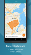
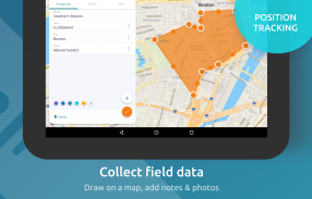
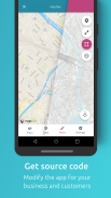
See your GPS position on your own maps. Draw points, polygons and lines on the maps. Collect field data and notes related to a location, attach a photo and fill custom properties.
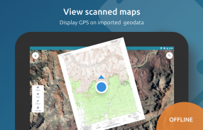
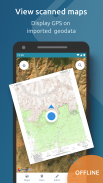
Display offline maps generated with MapTiler (https://www.maptiler.com).
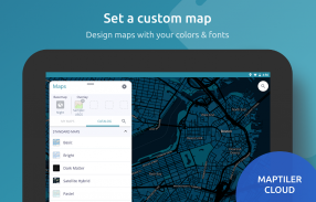
Choose from various basemaps like street and satellite. Preview on a mobile device the map you previously designed with own colors and fonts in MapTiler Cloud.
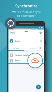
The app supports GeoJSON and MBTiles formats and data synchronization between multiple devices and desktop computer using cloud. I it easy to share the data with other people and collaborate! Perfect for mobile data collection for GIS and surveys.
Import scanned hiking maps, PDF maps, drone aerial imagery, nautical charts for sailing and navigation with a boat or a yacht, fishing maps, aeronautical charts for flight planning by pilots, parcels and city plans and other opendata from local government. OpenStreetMap vector maps are powered by OpenMapTiles project (the successor of OSM2VectorTiles). Maps can come from existing tile servers with OGC WMTS, TileJSON or XYZ tiles from.
Supported geodata formats by MapTiler: GeoTIFF, TIFF, JPEG, ECW, SID / MrSID, NOAA KAP / BSB, DEM, OziExplorer OZI OZF2 & OZFX3, WebP, JP2, JPEG2000, GeoJP2, Erdas, Grass, Safe, Sentinel2, SRTM, NASA imagery, USGS map sheets, exports from ESRI ArcGIS, ArcSDE, etc.
The GeoJSON can be converted from / to: ESRI ShapeFile (SHP), DXF, DWG, GPX, CSV and KML.
သင့်ကိုယ်ပိုင်မြေပုံပေါ်တွင်သင်၏ GPS စနစ်အနေအထားကိုကြည့်ပါ။ မြေပုံပေါ်အချက်များ, အနားနှင့်လိုင်းများဆွဲပါ။ တစ်ဦးတည်နေရာနှင့်ဆက်စပ်သောလယ်ပြင်အချက်အလက်များနှင့်မှတ်စုစုဆောင်းတဲ့ဓာတ်ပုံကို attach နှင့်ထုံးစံဂုဏ်သတ္တိများဖြည့်ပါ။
MapTiler (https://www.maptiler.com) နဲ့ထုတ်လုပ်ပြီးအော့ဖ်လိုင်းမြေပုံများကိုဖော်ပြရန်။
လမ်းနှင့်ဂြိုဟ်တုများကဲ့သို့အမျိုးမျိုးသော basemaps ကနေရွေးချယ်ပါ။ မိုဘိုင်း device ကိုသင်ယခင်က MapTiler တိမ်တိုက်အတွက်ကိုယ်ပိုင်အရောင်အဆင်းနဲ့ဖောင့်တွေနဲ့ဒီဇိုင်းရေးဆွဲမြေပုံပေါ်တွင် preview ။
ဒီ app GeoJSON နှင့် MBTiles ကို formats နဲ့ cloud သုံးပြီးမျိုးစုံပစ္စည်းတွေနဲ့ Desktop ကွန်ပျူတာအကြားဒေတာထပ်တူထောက်ခံပါတယ်။ ငါကအခြားလူတွေနဲ့အတူ data share နှင့်ပူးပေါင်းကလွယ်ကူ! GIS နှင့်စစ်တမ်းများအဘို့အမိုဘိုင်းဒေတာစုဆောင်းခြင်းများအတွက်စုံလင်သော။
သွင်းကုန်မြေပုံများ, PDF ကိုမြေပုံများ, မောင်းသူမဲ့လေယာဉ်ဝေဟင်ပုံရိပ်တစ်လှေတစ်ခုသို့မဟုတ်ရွက်လှေနှင့်အတူရွက်နှင့်အညွှန်းများအတွက်ရေကြောင်းဇယား, ငါးဖမ်းမြေပုံများ, လေယာဉ်မှူး, ချောထုပ်များနှင့်မြို့အစီအစဉ်များနှင့်ဒေသခံအစိုးရအနေဖြင့်အခြားအ opendata အားဖြင့်လေယာဉ်ခရီးစဉ်အစီအစဉ်ရေးဆွဲခြင်းများအတွက်လေကြောင်းဇယားတောင်တက် scan ဖတ်။ OpenStreetMap အားနည်းချက်ကိုပြမြေပုံများ OpenMapTiles စီမံကိန်းကို (OSM2VectorTiles ၏ဆက်ခံ) က powered နေကြသည်။ မြေပုံများမှ OGC WMTS, TileJSON သို့မဟုတ် XYZ အုပ်ကြွပ်နှင့်အတူလက်ရှိ tile ကိုဆာဗာများမှလာနိုင်ပါတယ်။
GeoTIFF, TIFF, JPEG, ECW, SID / MrSID, NOAA Kap / BSB, ဒီမိုကရက်တစ်, OziExplorer OZI OZF2 & OZFX3, WebP, JP2, JPEG2000, GeoJP2, Erdas, မြက်, ကို Safe, Sentinel2, SRTM, နာဆာ: MapTiler ကထောက်ခံ geodata ပုံစံများ ပုံရိပ်, USGS မြေပုံစာရွက်များ, ESRI ArcGIS, ArcSDE ကနေပို့ကုန်, etc
ESRI ShapeFile (SHP), DXF, DWG, GPX, CSV ဖိုင်နဲ့ KML: အဆိုပါ GeoJSON ထံမှ / ကူးပြောင်းနိုင်ပါတယ်။
MapTiler Mobile - ဗားရွင္း 2.0.1
(12-03-2020)MapTiler Mobile - APK သတင္းအခ်က္အလက္
APK ဗားရွင္း: 2.0.1package: com.maptiler.geoeditorMapTiler Mobile ၏ ေနာက္ဆုံးဗားရွင္း
အျခား ဗားရွင္းမ်ား


က႑တူအက္ပ္မ်ား

သင္ႏွစ္သက္ႏိုင္သည္မ်ားမွာ...


